
Make a donation
Gear up for your next adventure:
As an Amazon Associate, this site earns from qualifying purchases at no extra cost to you.
Shandon topographic map
Click on the map to display elevation.
Make a donation
Gear up for your next adventure:
As an Amazon Associate, this site earns from qualifying purchases at no extra cost to you.
About this map
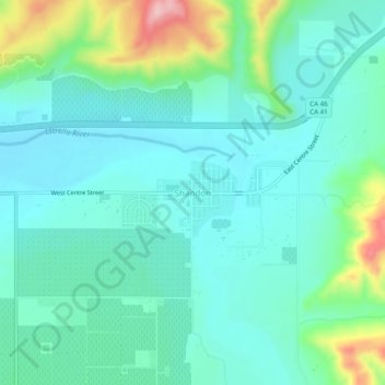
Name: Shandon topographic map, elevation, terrain.
Average elevation: 1,132 ft
Minimum elevation: 981 ft
Maximum elevation: 1,650 ft
San Luis Obispo County trails, hiking, mountain biking, running and outdoor activities
Make a donation
Gear up for your next adventure:
As an Amazon Associate, this site earns from qualifying purchases at no extra cost to you.
Other topographic maps
Click on a map to view its topography, its elevation and its terrain.
Morro Strand State Beach
United States > California > San Luis Obispo County > Morro Bay
Average elevation: 210 ft
Morro Bay State Park
United States > California > San Luis Obispo County > Morro Bay
Average elevation: 121 ft
Laguna Lake
United States > California > San Luis Obispo County > San Luis Obispo
Average elevation: 207 ft
Make a donation
Gear up for your next adventure:
As an Amazon Associate, this site earns from qualifying purchases at no extra cost to you.
Montaña de Oro State Park
United States > California > San Luis Obispo County > Cuesta-by-the-Sea
Average elevation: 308 ft