
Make a donation
Gear up for your next adventure:
As an Amazon Associate, this site earns from qualifying purchases at no extra cost to you.
Ernage topographic map
Click on the map to display elevation.
Make a donation
Gear up for your next adventure:
As an Amazon Associate, this site earns from qualifying purchases at no extra cost to you.
Ernage
Ernage heeft een oppervlakte van 825 ha. Het ligt op een hooggelegen plateau met verspreide heuvels. Het dorp ligt op 148 m hoogte. De bodem bestaat uit klei-, zand- en moerasgrond.
Make a donation
Gear up for your next adventure:
As an Amazon Associate, this site earns from qualifying purchases at no extra cost to you.
About this map
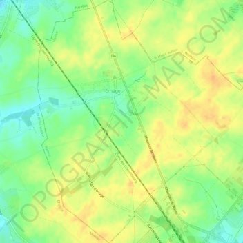
Name: Ernage topographic map, elevation, terrain.
Location: Ernage, Gembloers, Namen, Wallonië, België (50.57088 4.65584 50.60805 4.69845)
Average elevation: 515 ft
Minimum elevation: 453 ft
Maximum elevation: 558 ft
Make a donation
Gear up for your next adventure:
As an Amazon Associate, this site earns from qualifying purchases at no extra cost to you.
Other topographic maps
Click on a map to view its topography, its elevation and its terrain.