
Thank you for supporting this site ❤️
Make a donation
Make a donation
Gear up for your next adventure:
As an Amazon Associate, this site earns from qualifying purchases at no extra cost to you.
Falconara topographic map
Click on the map to display elevation.
Thank you for supporting this site ❤️
Make a donation
Make a donation
Gear up for your next adventure:
As an Amazon Associate, this site earns from qualifying purchases at no extra cost to you.
About this map
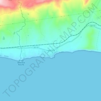
Name: Falconara topographic map, elevation, terrain.
Location: Falconara, Butera, Caltanissetta, Sicily, 93011, Italy (37.09085 14.03118 37.13085 14.07118)
Average elevation: 131 ft
Minimum elevation: 0 ft
Maximum elevation: 810 ft
Thank you for supporting this site ❤️
Make a donation
Make a donation
Gear up for your next adventure:
As an Amazon Associate, this site earns from qualifying purchases at no extra cost to you.