
Make a donation
Gear up for your next adventure:
As an Amazon Associate, this site earns from qualifying purchases at no extra cost to you.
Kaunas County topographic map
Click on the map to display elevation.
Make a donation
Gear up for your next adventure:
As an Amazon Associate, this site earns from qualifying purchases at no extra cost to you.
About this map
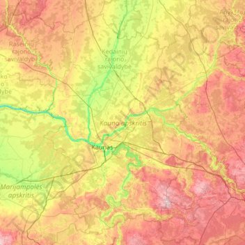
Name: Kaunas County topographic map, elevation, terrain.
Location: Kaunas County, Lithuania (54.45468 22.67003 55.57674 24.81152)
Average elevation: 305 ft
Minimum elevation: 30 ft
Maximum elevation: 804 ft
Make a donation
Gear up for your next adventure:
As an Amazon Associate, this site earns from qualifying purchases at no extra cost to you.
Other topographic maps
Click on a map to view its topography, its elevation and its terrain.
Make a donation
Gear up for your next adventure:
As an Amazon Associate, this site earns from qualifying purchases at no extra cost to you.
Make a donation
Gear up for your next adventure:
As an Amazon Associate, this site earns from qualifying purchases at no extra cost to you.
Aukštojas
Lithuania > Vilnius County > Medininkai Eldership > Juozapinė
Aukštojas Hill is the highest point in all of Lithuania; it is located in the Medininkai Highlands, Migūnai forestry, approximately 24 kilometres (15 mi) southeast of the capital city of Vilnius. Its elevation was measured in 2004 at 293.84 metres (964.0 feet) by specialists at the Institute of Geodesy at…
Average elevation: 866 ft
Make a donation
Gear up for your next adventure:
As an Amazon Associate, this site earns from qualifying purchases at no extra cost to you.
Make a donation
Gear up for your next adventure:
As an Amazon Associate, this site earns from qualifying purchases at no extra cost to you.