
Make a donation
Gear up for your next adventure:
As an Amazon Associate, this site earns from qualifying purchases at no extra cost to you.
Anthony Township topographic map
Click on the map to display elevation.
Make a donation
Gear up for your next adventure:
As an Amazon Associate, this site earns from qualifying purchases at no extra cost to you.
About this map
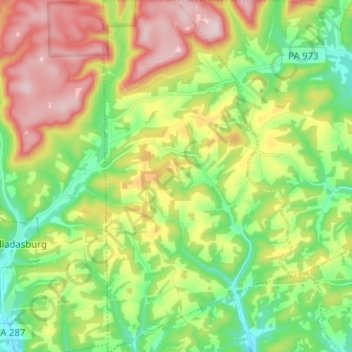
Name: Anthony Township topographic map, elevation, terrain.
Average elevation: 1,070 ft
Minimum elevation: 571 ft
Maximum elevation: 1,814 ft
Lycoming County trails, hiking, mountain biking, running and outdoor activities
Make a donation
Gear up for your next adventure:
As an Amazon Associate, this site earns from qualifying purchases at no extra cost to you.
Other topographic maps
Click on a map to view its topography, its elevation and its terrain.
Waterville
United States > Pennsylvania > Lycoming County > Cummings Township
Average elevation: 1,273 ft
English Center
United States > Pennsylvania > Lycoming County > Pine Township
Average elevation: 1,457 ft
Make a donation
Gear up for your next adventure:
As an Amazon Associate, this site earns from qualifying purchases at no extra cost to you.
Elimsport
United States > Pennsylvania > Lycoming County > Washington Township
Average elevation: 630 ft
Make a donation
Gear up for your next adventure:
As an Amazon Associate, this site earns from qualifying purchases at no extra cost to you.
Buttonwood
United States > Pennsylvania > Lycoming County > Jackson Township
Average elevation: 1,788 ft
Cove Mountain
United States > Pennsylvania > Lycoming County > Gamble Township
Average elevation: 1,398 ft
Cogan Station
United States > Pennsylvania > Lycoming County > Hepburn Township
Average elevation: 794 ft
Make a donation
Gear up for your next adventure:
As an Amazon Associate, this site earns from qualifying purchases at no extra cost to you.
Bastress
United States > Pennsylvania > Lycoming County > Bastress Township
Average elevation: 1,237 ft
Level Corner
United States > Pennsylvania > Lycoming County > Piatt Township
Average elevation: 725 ft
Loyalsockville
United States > Pennsylvania > Lycoming County > Upper Fairfield Township
Average elevation: 860 ft
Make a donation
Gear up for your next adventure:
As an Amazon Associate, this site earns from qualifying purchases at no extra cost to you.
Raccoon Mountain
United States > Pennsylvania > Lycoming County > Armstrong Township
Average elevation: 1,243 ft
Make a donation
Gear up for your next adventure:
As an Amazon Associate, this site earns from qualifying purchases at no extra cost to you.