
Jeffersonville topographic map
Interactive map
Click on the map to display elevation.
About this map
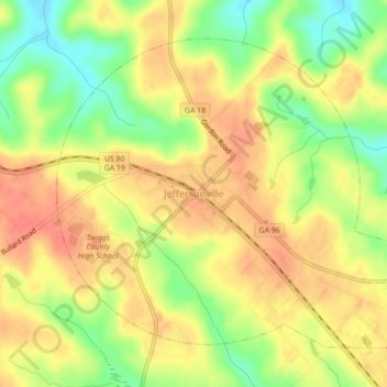
Name: Jeffersonville topographic map, elevation, terrain.
Location: Jeffersonville, Twiggs County, Georgia, United States (32.67289 -83.36253 32.70227 -83.31897)
Average elevation: 486 ft
Minimum elevation: 374 ft
Maximum elevation: 564 ft
Twiggs County trails, hiking, mountain biking, running and outdoor activities
Other topographic maps
Click on a map to view its topography, its elevation and its terrain.