
Thank you for supporting this site ❤️
Make a donation
Make a donation
Gear up for your next adventure:
As an Amazon Associate, this site earns from qualifying purchases at no extra cost to you.
Lumba-Bayabao topographic map
Click on the map to display elevation.
Thank you for supporting this site ❤️
Make a donation
Make a donation
Gear up for your next adventure:
As an Amazon Associate, this site earns from qualifying purchases at no extra cost to you.
About this map
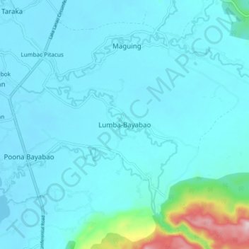
Name: Lumba-Bayabao topographic map, elevation, terrain.
Location: Lumba-Bayabao, Lanao del Sur, Bangsamoro, 9712, Philippines (7.82344 124.33051 7.90344 124.41051)
Average elevation: 2,438 ft
Minimum elevation: 2,287 ft
Maximum elevation: 3,734 ft
Thank you for supporting this site ❤️
Make a donation
Make a donation
Gear up for your next adventure:
As an Amazon Associate, this site earns from qualifying purchases at no extra cost to you.
Other topographic maps
Click on a map to view its topography, its elevation and its terrain.