Geolocate

Klang topographic map

Click on the map to display elevation.

About this map

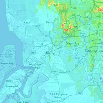
Name: Klang topographic map, elevation, terrain.

Location: Klang, Selangor, 41400, Malaysia (2.88715 101.28921 3.20715 101.60921)

Average elevation: 43 ft

Minimum elevation: -92 ft

Maximum elevation: 827 ft

Gear up for your next adventure:

🧥Men's Rain Shells - Premium waterproof and breathable jackets for mountain weather
🚗GPS Dash Cams - Record your scenic drives through mountain passes and canyons
🔌USB Car Charger - Car charger for on‑the‑go power needs
👟Trail Running Shoes - Lightweight shoes for trail runners
🪶Survival Guide Book - Expert advice for emergency preparedness

As an Amazon Associate, this site earns from qualifying purchases at no extra cost to you.