Geolocate

Montaña topographic map

Click on the map to display elevation.

About this map

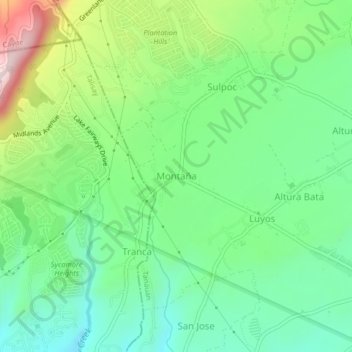
Name: Montaña topographic map, elevation, terrain.

Location: Montaña, Tanauan, Batangas, Calabarzon, 4232, Philippines (14.10803 121.04256 14.14803 121.08256)

Average elevation: 666 ft

Minimum elevation: 174 ft

Maximum elevation: 1,690 ft

Other topographic maps

Click on a map to view its topography, its elevation and its terrain.

Maria Paz

Philippines > Batangas > Tanauan

Average elevation: 210 ft

Barangay 3

Philippines > Batangas > Tanauan > Hidalgo

Average elevation: 518 ft

Barangay 5

Philippines > Batangas > Tanauan > Hidalgo

Average elevation: 505 ft

Suplang

Philippines > Batangas > Tanauan

Average elevation: 810 ft

Barangay 5

Philippines > Batangas > Tanauan > Hidalgo

Average elevation: 505 ft

Gear up for your next adventure:

📖Nature Tracking Books - Learn to track wildlife and terrain
🧼Biodegradable Camping Soap - Eco‑friendly soap for outdoor hygiene
🌄Hiking Binoculars - Compact binoculars for scenic views and trail spotting
🪶Trail Camera - Capture wildlife on your hikes
🧭Compass with Lanyard - Easy‑carry compass for navigation

As an Amazon Associate, this site earns from qualifying purchases at no extra cost to you.