Geolocate

Edwards topographic map

Click on the map to display elevation.

About this map

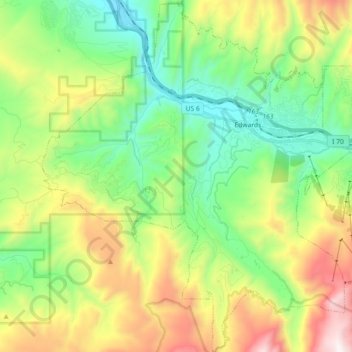
Name: Edwards topographic map, elevation, terrain.

Location: Edwards, Eagle County, Colorado, 81632, United States (39.55483 -106.69977 39.69406 -106.54128)

Average elevation: 8,524 ft

Minimum elevation: 7,008 ft

Maximum elevation: 11,345 ft

Eagle County trails, hiking, mountain biking, running and outdoor activities

Gear up for your next adventure:

🛠️Backpacking Tool Kit - Essential toolkit for outdoor repairs
🪑Ultralight Camp Chairs - Portable seating for resting after a long day of mapping
🧣Hiking Neck Gaiter - Multi‑use neck protection for outdoor weather
🪵Folding Camp Saw - Compact saw for wood and campsite work
🎒Outdoor Daypacks - Lightweight backpacks designed for carrying maps and essential gear

As an Amazon Associate, this site earns from qualifying purchases at no extra cost to you.