Geolocate

Arvada topographic map

Click on the map to display elevation.

About this map

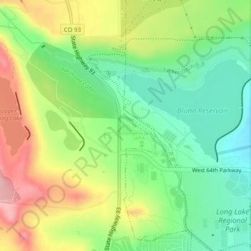
Name: Arvada topographic map, elevation, terrain.

Location: Arvada, Jefferson County, Colorado, United States (39.82002 -105.22167 39.82199 -105.21766)

Average elevation: 5,892 ft

Minimum elevation: 5,679 ft

Maximum elevation: 6,191 ft

Colorado trails, hiking, mountain biking, running and outdoor activities

Gear up for your next adventure:

☀️Outdoor Sunscreen - High protection sunscreen for outdoor activities
🧦Hiking Socks - Comfortable socks to prevent blisters on long hikes
🥾Men's Hiking Boots - Durable, waterproof footwear for rugged terrain and steep inclines
🎁Geography Themed Gifts - Unique gift ideas for map lovers and geography enthusiasts
💧Water Filtration Bottles - Safely drink from streams and lakes while exploring

As an Amazon Associate, this site earns from qualifying purchases at no extra cost to you.