
Make a donation
Gear up for your next adventure:
As an Amazon Associate, this site earns from qualifying purchases at no extra cost to you.
Herzogstand topographic map
Click on the map to display elevation.
Make a donation
Gear up for your next adventure:
As an Amazon Associate, this site earns from qualifying purchases at no extra cost to you.
Herzogstand
Der Herzogstand ist ein Berg in den Bayerischen Voralpen mit 1731 m ü. NHN nordwestlich des Walchensees. Er gehört zum Gebiet der Gemeinde Kochel am See und bildet mit seinem Nachbarn Heimgarten einen Höhenzug, der dem Estergebirge vorgelagert ist und nach Norden in das Bayerische Alpenvorland abfällt.
Make a donation
Gear up for your next adventure:
As an Amazon Associate, this site earns from qualifying purchases at no extra cost to you.
About this map
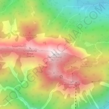
Name: Herzogstand topographic map, elevation, terrain.
Average elevation: 4,058 ft
Minimum elevation: 2,484 ft
Maximum elevation: 5,587 ft
Make a donation
Gear up for your next adventure:
As an Amazon Associate, this site earns from qualifying purchases at no extra cost to you.
Other topographic maps
Click on a map to view its topography, its elevation and its terrain.
Kochelsee
Deutschland > Bayern > Landkreis Bad Tölz-Wolfratshausen > Kochel am See
Average elevation: 2,103 ft
82431
Deutschland > Bayern > Landkreis Bad Tölz-Wolfratshausen > Kochel am See
Average elevation: 2,612 ft
Walchensee
Deutschland > Bayern > Landkreis Bad Tölz-Wolfratshausen > Kochel am See
Der Walchensee ist einer der tiefsten (maximale Tiefe: 190 m) und zugleich einer der größten (16,40 km²) Alpenseen Deutschlands. Er liegt 75 km südlich von München in den Bayerischen Voralpen, auf 800 m Meereshöhe und mit seiner gesamten Fläche einschließlich der Insel Sassau in der Gemeinde Kochel am…
Average elevation: 3,074 ft
Urfeld
Deutschland > Bayern > Landkreis Bad Tölz-Wolfratshausen > Kochel am See
Average elevation: 3,009 ft
Make a donation
Gear up for your next adventure:
As an Amazon Associate, this site earns from qualifying purchases at no extra cost to you.
Kochelsee
Deutschland > Bayern > Landkreis Bad Tölz-Wolfratshausen > Kochel am See
Average elevation: 2,103 ft