
Make a donation
Gear up for your next adventure:
As an Amazon Associate, this site earns from qualifying purchases at no extra cost to you.
Monte Frerone topographic map
Click on the map to display elevation.
Make a donation
Gear up for your next adventure:
As an Amazon Associate, this site earns from qualifying purchases at no extra cost to you.
About this map
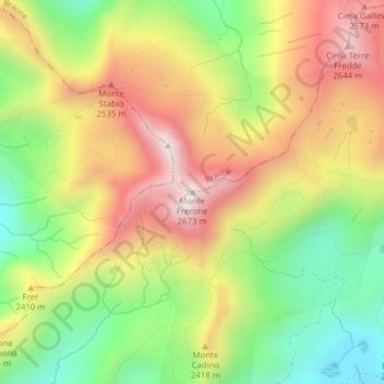
Name: Monte Frerone topographic map, elevation, terrain.
Average elevation: 7,536 ft
Minimum elevation: 6,440 ft
Maximum elevation: 8,684 ft
Make a donation
Gear up for your next adventure:
As an Amazon Associate, this site earns from qualifying purchases at no extra cost to you.
Other topographic maps
Click on a map to view its topography, its elevation and its terrain.
Lago della Vacca
Italia > Lombardia > Brescia > Breno
Il lago, vista la sua altitudine, è raggiungibile a piedi o in mountain bike mediante sentieri, oppure in elicottero (la piazzola di atterraggio è collocata nelle vicinanze del rifugio Tita Secchi). Un primo percorso ha inizio al rifugio Bazena (1800 m), posto lungo la ex SS 345 e quindi raggiungibile in…
Average elevation: 7,762 ft