
Make a donation
Gear up for your next adventure:
As an Amazon Associate, this site earns from qualifying purchases at no extra cost to you.
Cutris topographic map
Click on the map to display elevation.
Make a donation
Gear up for your next adventure:
As an Amazon Associate, this site earns from qualifying purchases at no extra cost to you.
About this map
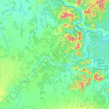
Name: Cutris topographic map, elevation, terrain.
Location: Cutris, San Carlos, Alajuela, 21011, Costa Rica (10.47102 -84.53890 10.91669 -84.18582)
Average elevation: 259 ft
Minimum elevation: 43 ft
Maximum elevation: 1,155 ft
Make a donation
Gear up for your next adventure:
As an Amazon Associate, this site earns from qualifying purchases at no extra cost to you.
Other topographic maps
Click on a map to view its topography, its elevation and its terrain.
Make a donation
Gear up for your next adventure:
As an Amazon Associate, this site earns from qualifying purchases at no extra cost to you.
Asentamiento Santa Rosa
Costa Rica > Alajuela > San Carlos > Pocosol > Santa Rosa
Average elevation: 377 ft
Make a donation
Gear up for your next adventure:
As an Amazon Associate, this site earns from qualifying purchases at no extra cost to you.