Geolocate

Hatching Green topographic map

Click on the map to display elevation.

About this map

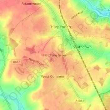
Name: Hatching Green topographic map, elevation, terrain.

Location: Hatching Green, St Albans, Hertfordshire, England, AL5 2JS, United Kingdom (51.78416 -0.37823 51.82416 -0.33823)

Average elevation: 390 ft

Minimum elevation: 269 ft

Maximum elevation: 459 ft

Other topographic maps

Click on a map to view its topography, its elevation and its terrain.

St Albans

United Kingdom > England > Hertfordshire > St Albans

St Albans was an ancient borough created following the dissolution of the monastery in 1539. It consisted of the ancient parish of St Albans (also known as the Abbey parish) and parts of St Michael and St Peter. The municipal corporation was reformed by the Municipal Corporations Act 1835 and the boundary was…

Average elevation: 328 ft

Sandridge

United Kingdom > England > Hertfordshire > St Albans

Average elevation: 344 ft

London Colney

United Kingdom > England > Hertfordshire > St Albans

Average elevation: 246 ft

Sandridge

United Kingdom > England > Hertfordshire > St Albans

Average elevation: 344 ft

Wheathampstead

United Kingdom > England > Hertfordshire > St Albans

Average elevation: 358 ft

Redbourn

United Kingdom > England > Hertfordshire > St Albans

Average elevation: 397 ft

River Ver

United Kingdom > England > Hertfordshire > St Albans

Average elevation: 377 ft

Colney Heath

United Kingdom > England > Hertfordshire > St Albans

Average elevation: 266 ft

Gear up for your next adventure:

🎒Gear Packing Cubes - Organize your backpack efficiently
🥤Water Filter Bottle - All‑in‑one filter bottle for safe hydration
🪶Camp Gear Gift Set - Perfect gift bundle for outdoor fans
🪶Wildlife Field Guides - Learn animal tracking and species ID
🩹Survival Bandages - High‑quality bandages for emergencies

As an Amazon Associate, this site earns from qualifying purchases at no extra cost to you.