
Make a donation
Gear up for your next adventure:
As an Amazon Associate, this site earns from qualifying purchases at no extra cost to you.
Amajari topographic map
Click on the map to display elevation.
Make a donation
Gear up for your next adventure:
As an Amazon Associate, this site earns from qualifying purchases at no extra cost to you.
About this map
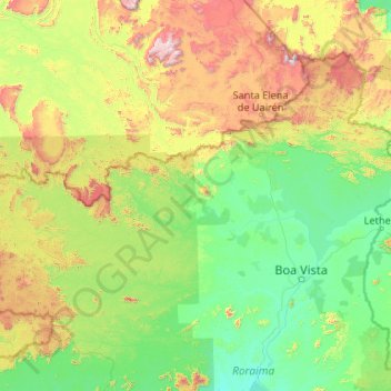
Name: Amajari topographic map, elevation, terrain.
Average elevation: 1,476 ft
Minimum elevation: 131 ft
Maximum elevation: 9,134 ft
Make a donation
Gear up for your next adventure:
As an Amazon Associate, this site earns from qualifying purchases at no extra cost to you.
Other topographic maps
Click on a map to view its topography, its elevation and its terrain.
Serra do Tepequém
A serra do Tepequém é um acidente geográfico localizado no município brasileiro de Amajari, estado de Roraima. Situa-se a 210 km da capital, Boa Vista, e apresenta atrativos como o platô da serra do Tepequém, que chega a 1.022m de altitude. A economia baseia-se no turismo e no artesanato.
Average elevation: 1,332 ft