Geolocate

Thayne topographic map

Click on the map to display elevation.

Thayne

Thayne is located at 42°55′11″N 111°0′3″W / 42.91972°N 111.00083°W / 42.91972; -111.00083 (42.919754, –111.000714), at 5906 feet in elevation. It sits in the northern portion of Wyoming's grassy Star Valley, close to the Salt River. Thayne is surrounded by green grassland and ranches, with forested mountains at the valley's edge.

Wikipedia (CC-BY-SA 3.0)

About this map

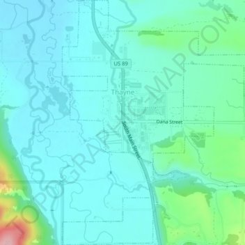
Name: Thayne topographic map, elevation, terrain.

Location: Thayne, Lincoln County, Wyoming, 83127, United States (42.90253 -111.01238 42.93177 -110.97281)

Average elevation: 5,951 ft

Minimum elevation: 5,850 ft

Maximum elevation: 6,434 ft

Lincoln County trails, hiking, mountain biking, running and outdoor activities

Other topographic maps

Click on a map to view its topography, its elevation and its terrain.

Freedom

United States > Wyoming > Lincoln County

Average elevation: 5,820 ft

Salt River Range

United States > Wyoming > Lincoln County

Average elevation: 7,887 ft

Wyoming Peak

United States > Wyoming > Lincoln County

Average elevation: 10,197 ft

Wyoming Range

United States > Wyoming > Lincoln County

Average elevation: 7,733 ft

Gear up for your next adventure:

📌Outdoor GPS Map App - Apps and devices for digital topographic navigation
🧭Pro Hiking Compasses - High-accuracy liquid-filled compasses for topographic orientation
🔦Compact Flashlight - Reliable flashlight for emergencies
🔥Camping Stove - Portable stove for camping and backcountry cooking
🎒Hydration Pack - Hands‑free water reservoir for long hikes

As an Amazon Associate, this site earns from qualifying purchases at no extra cost to you.