Geolocate

La Rrinconada topographic map

Click on the map to display elevation.

About this map

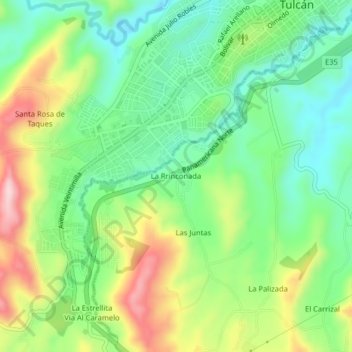
Name: La Rrinconada topographic map, elevation, terrain.

Location: La Rrinconada, Urbina, Tulcán, Carchi, 040105, Ecuador (0.77192 -77.75100 0.81192 -77.71100)

Average elevation: 9,767 ft

Minimum elevation: 9,446 ft

Maximum elevation: 10,312 ft

Other topographic maps

Click on a map to view its topography, its elevation and its terrain.

Tulcán

Ecuador > Carchi > Tulcán

Average elevation: 10,210 ft

Gear up for your next adventure:

👓Polarized Sunglasses - Outdoor sunglasses for glare reduction
🪶Trail Camera - Capture wildlife on your hikes
🥄Camping Utensil Set - Lightweight utensils for outdoor meals
📶Satellite Messenger - Communication device off‑grid
🏔️Mountain Trail Maps - High‑detail maps for popular peaks

As an Amazon Associate, this site earns from qualifying purchases at no extra cost to you.