
Morven topographic map
Interactive map
Click on the map to display elevation.
About this map
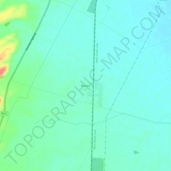
Name: Morven topographic map, elevation, terrain.
Location: Morven, Waimate District, Canterbury, New Zealand (-44.83778 171.08821 -44.79778 171.12821)
Average elevation: 72 ft
Minimum elevation: 30 ft
Maximum elevation: 240 ft
Other topographic maps
Click on a map to view its topography, its elevation and its terrain.
Glenavy
New Zealand > Canterbury > Waimate District
Glenavy, Waimate District, Canterbury, 7980, New Zealand
Average elevation: 75 ft
Esk Valley
New Zealand > Canterbury > Waimate District
Esk Valley, Waimate District, Canterbury, New Zealand
Average elevation: 305 ft
Waimate
New Zealand > Canterbury > Waimate District
Waimate, Waimate District, Canterbury, 7924, New Zealand
Average elevation: 328 ft
Waitaki River
New Zealand > Canterbury > Waimate District > Glenavy
Waitaki River, Glenavy, Waimate District, Canterbury, New Zealand
Average elevation: 62 ft