
Thank you for supporting this site ❤️
Make a donation
Make a donation
Gear up for your next adventure:
As an Amazon Associate, this site earns from qualifying purchases at no extra cost to you.
Liri topographic map
Click on the map to display elevation.
Thank you for supporting this site ❤️
Make a donation
Make a donation
Gear up for your next adventure:
As an Amazon Associate, this site earns from qualifying purchases at no extra cost to you.
About this map
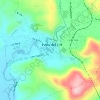
Name: Liri topographic map, elevation, terrain.
Location: Liri, Isola del Liri, Frosinone, Lazio, 03036, Italia (41.67726 13.57133 41.67827 13.57371)
Average elevation: 902 ft
Minimum elevation: 673 ft
Maximum elevation: 1,421 ft
Thank you for supporting this site ❤️
Make a donation
Make a donation
Gear up for your next adventure:
As an Amazon Associate, this site earns from qualifying purchases at no extra cost to you.