
Thank you for supporting this site ❤️
Make a donation
Make a donation
Gear up for your next adventure:
As an Amazon Associate, this site earns from qualifying purchases at no extra cost to you.
Huiracocha topographic map
Click on the map to display elevation.
Thank you for supporting this site ❤️
Make a donation
Make a donation
Gear up for your next adventure:
As an Amazon Associate, this site earns from qualifying purchases at no extra cost to you.
About this map
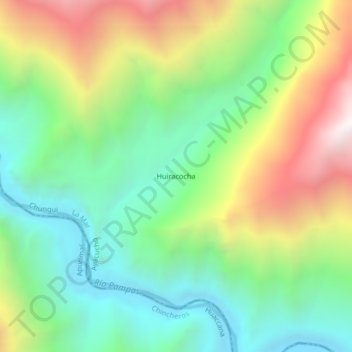
Name: Huiracocha topographic map, elevation, terrain.
Location: Huiracocha, Chungui, La Mar, Ayacucho, Perú (-13.32877 -73.63556 -13.28877 -73.59556)
Average elevation: 6,414 ft
Minimum elevation: 4,475 ft
Maximum elevation: 9,711 ft
Thank you for supporting this site ❤️
Make a donation
Make a donation
Gear up for your next adventure:
As an Amazon Associate, this site earns from qualifying purchases at no extra cost to you.