
Make a donation
Gear up for your next adventure:
As an Amazon Associate, this site earns from qualifying purchases at no extra cost to you.
Pal topographic map
Click on the map to display elevation.
Make a donation
Gear up for your next adventure:
As an Amazon Associate, this site earns from qualifying purchases at no extra cost to you.
Pal
Pal village is located at 21°21′43″N 75°54′11″E / 21.361853°N 75.902929°E / 21.361853; 75.902929. It has average elevation of 397 meters from the sea level. Due to its high elevation and isolated nature in Satpura mountains surrounded by forests, Pal is locally known as picnic spot and hill station. Forest surrounding Pal village falls under protected area of Yawal Wildlife Sanctuary, but the village itself falls under the jurisdictional area of the Raver tehsil.
Make a donation
Gear up for your next adventure:
As an Amazon Associate, this site earns from qualifying purchases at no extra cost to you.
About this map
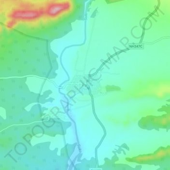
Name: Pal topographic map, elevation, terrain.
Location: Pal, Raver, Jalgaon, Maharashtra, India (21.34139 75.88252 21.38139 75.92252)
Average elevation: 1,368 ft
Minimum elevation: 1,217 ft
Maximum elevation: 1,900 ft
Make a donation
Gear up for your next adventure:
As an Amazon Associate, this site earns from qualifying purchases at no extra cost to you.