Geolocate
Thank you for supporting this site ❤️Make a donation

Cow Lake topographic map

Click on the map to display elevation.

About this map

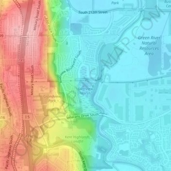
Name: Cow Lake topographic map, elevation, terrain.

Location: Cow Lake, Kent, King County, Washington, United States (47.39980 -122.27873 47.40102 -122.27642)

Average elevation: 167 ft

Minimum elevation: 7 ft

Maximum elevation: 489 ft

Other topographic maps

Click on a map to view its topography, its elevation and its terrain.

East Hill

United States > Washington > King County > Kent

East Hill, Kent, King County, Washington, 98030, United States

Average elevation: 354 ft

In order to remain free and to keep improving, this site uses cookies created by Google to compile visit statistics and display personalized advertisements.

How is the collected data used?