
Make a donation
Gear up for your next adventure:
As an Amazon Associate, this site earns from qualifying purchases at no extra cost to you.
Overboelare topographic map
Click on the map to display elevation.
Make a donation
Gear up for your next adventure:
As an Amazon Associate, this site earns from qualifying purchases at no extra cost to you.
Overboelare
Het dorp ligt in de Denderstreek aan de Dender, in Zandlemig Vlaanderen, in een golvend landschap met hoogtes die variëren tussen 17m en 77m.
Make a donation
Gear up for your next adventure:
As an Amazon Associate, this site earns from qualifying purchases at no extra cost to you.
About this map
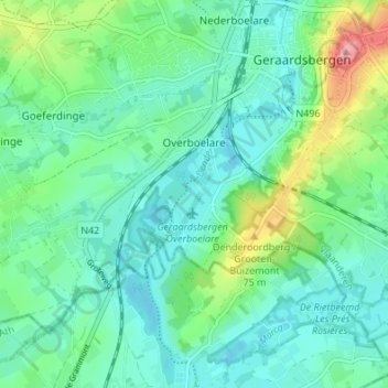
Name: Overboelare topographic map, elevation, terrain.
Average elevation: 112 ft
Minimum elevation: 33 ft
Maximum elevation: 344 ft
Make a donation
Gear up for your next adventure:
As an Amazon Associate, this site earns from qualifying purchases at no extra cost to you.
Other topographic maps
Click on a map to view its topography, its elevation and its terrain.
Denderarm Sluis Geeraardsbergen
België > Oost-Vlaanderen > Aalst > Geraardsbergen
Average elevation: 125 ft
Make a donation
Gear up for your next adventure:
As an Amazon Associate, this site earns from qualifying purchases at no extra cost to you.
Provinciaal Domein "De Gavers"
België > Oost-Vlaanderen > Aalst > Geraardsbergen
Average elevation: 75 ft