
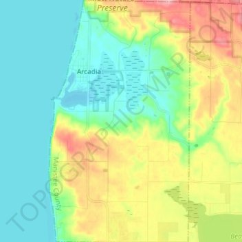
Arcadia Township topographic map
Interactive map
Click on the map to display elevation.
About this map
Name: Arcadia Township topographic map, elevation, terrain.
Average elevation: 709 ft
Minimum elevation: 564 ft
Maximum elevation: 1,017 ft
The unincorporated community of Arcadia is located within the township on M-22 on the shore of Lake Michigan. Arcadia is at 44°29′35″N 86°13′54″W / 44.49306°N 86.23167°W / 44.49306; -86.23167. The elevation is 587 feet (179 m) above sea level. The ZIP code is 49613.
Other topographic maps
Click on a map to view its topography, its elevation and its terrain.
Wellston
United States > Michigan > Manistee County
Wellston, Norman Township, Manistee County, Michigan, 49689, United States
Average elevation: 778 ft
Stronach Township
United States > Michigan > Manistee County
Stronach Township, Manistee County, Michigan, United States
Average elevation: 689 ft
Onekama Township
United States > Michigan > Manistee County
Onekama Township, Manistee County, Michigan, 49675, United States
Average elevation: 712 ft
Arcadia
United States > Michigan > Manistee County
Arcadia, Arcadia Township, Manistee County, Michigan, 49613, United States
Average elevation: 607 ft
Onekama
United States > Michigan > Manistee County
Onekama, Onekama Township, Manistee County, Michigan, United States
Average elevation: 650 ft
Dickson Township
United States > Michigan > Manistee County
Dickson Township, Manistee County, Michigan, 49619, United States
Average elevation: 817 ft
Manistee Township
United States > Michigan > Manistee County
Manistee Township, Manistee County, Michigan, United States
Average elevation: 659 ft
Virgin Island
United States > Michigan > Manistee County
Virgin Island, Dickson Township, Manistee County, Michigan, United States
Average elevation: 810 ft
Filer Charter Township
United States > Michigan > Manistee County
Filer Charter Township, Manistee County, Michigan, 49634, United States
Average elevation: 646 ft
Copemish
United States > Michigan > Manistee County
Copemish, Cleon Township, Manistee County, Michigan, United States
Average elevation: 820 ft