
Make a donation
Gear up for your next adventure:
As an Amazon Associate, this site earns from qualifying purchases at no extra cost to you.
El Condado topographic map
Click on the map to display elevation.
Make a donation
Gear up for your next adventure:
As an Amazon Associate, this site earns from qualifying purchases at no extra cost to you.
About this map
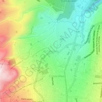
Name: El Condado topographic map, elevation, terrain.
Location: El Condado, Quito Canton, Pichincha, 170134, Ecuador (-0.12496 -78.52001 -0.08496 -78.48001)
Average elevation: 9,259 ft
Minimum elevation: 8,583 ft
Maximum elevation: 10,315 ft
Make a donation
Gear up for your next adventure:
As an Amazon Associate, this site earns from qualifying purchases at no extra cost to you.
Other topographic maps
Click on a map to view its topography, its elevation and its terrain.
Cumbaya
Ecuador > Pichincha > Quito Canton
At an elevation of 2200 m (7200 ft) above sea level, Cumbayá is lower than Quito and its climate is about 2 to 5 degrees Celsius warmer. Weather is semi tropical year-round, with a short rainy season.
Average elevation: 8,018 ft