
Make a donation
Gear up for your next adventure:
As an Amazon Associate, this site earns from qualifying purchases at no extra cost to you.
Opglabbeek topographic map
Click on the map to display elevation.
Make a donation
Gear up for your next adventure:
As an Amazon Associate, this site earns from qualifying purchases at no extra cost to you.
Opglabbeek
Opglabbeek ligt op het Kempens Plateau, op een hoogte van ongeveer 75 meter. In het zuidwesten is de invloed van de voormalige steenkoolmijnen merkbaar: twee terrils van de steenkoolmijn van Waterschei, waarvan één met een top tot 165 meter hoogte, liggen juist ten zuiden van de gemeentegrens. Hier vindt men, voornamelijk op het grondgebied van As, ook de natuurgebieden Klaverberg en Heiderbos.
Make a donation
Gear up for your next adventure:
As an Amazon Associate, this site earns from qualifying purchases at no extra cost to you.
About this map
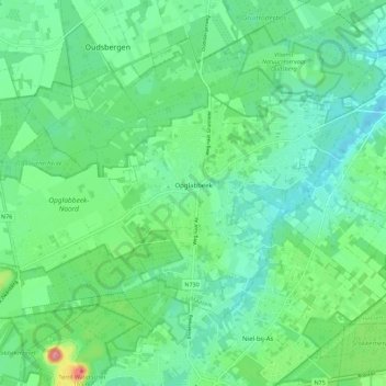
Name: Opglabbeek topographic map, elevation, terrain.
Average elevation: 259 ft
Minimum elevation: 164 ft
Maximum elevation: 538 ft
Make a donation
Gear up for your next adventure:
As an Amazon Associate, this site earns from qualifying purchases at no extra cost to you.
Other topographic maps
Click on a map to view its topography, its elevation and its terrain.
Make a donation
Gear up for your next adventure:
As an Amazon Associate, this site earns from qualifying purchases at no extra cost to you.