Geolocate

Arlington topographic map

Click on the map to display elevation.

About this map

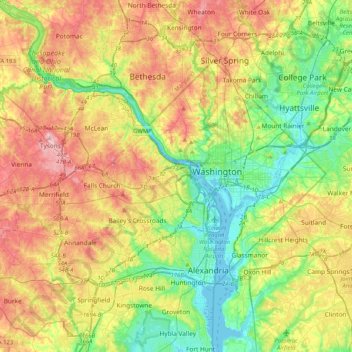
Name: Arlington topographic map, elevation, terrain.

Location: Arlington, Arlington County, Virginia, 22209, United States (38.73040 -77.24416 39.05040 -76.92416)

Average elevation: 217 ft

Minimum elevation: -10 ft

Maximum elevation: 525 ft

Arlington County trails, hiking, mountain biking, running and outdoor activities

Gear up for your next adventure:

🌡️Handheld Weather Meters - Measure wind, temp, and pressure for safe mountain travel
🏫Relief Map Kits - Hands-on tools for teaching landforms and elevation
🚁Photography Drones - Capture stunning aerial views of landforms and topography
🛡️Bear Spray Outdoor - Protection in bear country hikes
🔊Portable Camp Speaker - Music and alerts at camp

As an Amazon Associate, this site earns from qualifying purchases at no extra cost to you.