
Thank you for supporting this site ❤️
Make a donation
Make a donation
Gear up for your next adventure:
As an Amazon Associate, this site earns from qualifying purchases at no extra cost to you.
Icklesham topographic map
Click on the map to display elevation.
Thank you for supporting this site ❤️
Make a donation
Make a donation
Gear up for your next adventure:
As an Amazon Associate, this site earns from qualifying purchases at no extra cost to you.
About this map
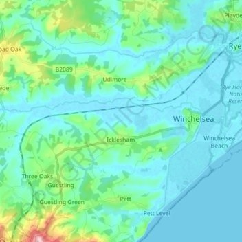
Name: Icklesham topographic map, elevation, terrain.
Location: Icklesham, Rother District, East Sussex, England, United Kingdom (50.90098 0.63598 50.94599 0.77641)
Average elevation: 85 ft
Minimum elevation: -7 ft
Maximum elevation: 554 ft
Thank you for supporting this site ❤️
Make a donation
Make a donation
Gear up for your next adventure:
As an Amazon Associate, this site earns from qualifying purchases at no extra cost to you.
Other topographic maps
Click on a map to view its topography, its elevation and its terrain.
Bewl Water
United Kingdom > England > East Sussex > Rother District > Ticehurst
Average elevation: 302 ft