
Make a donation
Gear up for your next adventure:
As an Amazon Associate, this site earns from qualifying purchases at no extra cost to you.
Staňkov topographic map
Click on the map to display elevation.
Make a donation
Gear up for your next adventure:
As an Amazon Associate, this site earns from qualifying purchases at no extra cost to you.
About this map
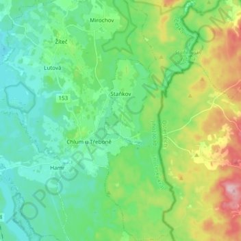
Name: Staňkov topographic map, elevation, terrain.
Location: Staňkov, okres Jindřichův Hradec, Southwest, Czechia (48.91942 14.94244 49.01742 15.00610)
Average elevation: 1,594 ft
Minimum elevation: 1,414 ft
Maximum elevation: 2,051 ft
Make a donation
Gear up for your next adventure:
As an Amazon Associate, this site earns from qualifying purchases at no extra cost to you.
Other topographic maps
Click on a map to view its topography, its elevation and its terrain.
Make a donation
Gear up for your next adventure:
As an Amazon Associate, this site earns from qualifying purchases at no extra cost to you.
Rakovické Chalupy
Czechia > Southwest > Jihočeský kraj > Mirotice > Rakovické Chalupy
Average elevation: 1,450 ft
Climbing terrain Jickovice
Czechia > Southwest > Jihočeský kraj > Jickovice
Average elevation: 1,358 ft