Geolocate

Polperro topographic map

Click on the map to display elevation.

About this map

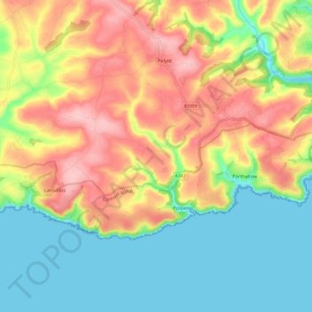
Name: Polperro topographic map, elevation, terrain.

Location: Polperro, Cornwall, England, United Kingdom (50.32368 -4.58331 50.36476 -4.46376)

Average elevation: 226 ft

Minimum elevation: 0 ft

Maximum elevation: 515 ft

Other topographic maps

Click on a map to view its topography, its elevation and its terrain.

Crumplehorn

United Kingdom > England > Cornwall > Polperro

Average elevation: 233 ft

Gear up for your next adventure:

🎒Hydration Pack - Hands‑free water reservoir for long hikes
🪶Paracord Bracelet - Survival bracelet with built‑in tools
😴Insulated Sleeping Pads - Compact and warm pads for high-elevation camping
🦟Ultrasonic Repellers - Create a bug-free zone at your camp or rest stop
🚗GPS Dash Cams - Record your scenic drives through mountain passes and canyons

As an Amazon Associate, this site earns from qualifying purchases at no extra cost to you.