
Thank you for supporting this site ❤️
Make a donation
Make a donation
Gear up for your next adventure:
As an Amazon Associate, this site earns from qualifying purchases at no extra cost to you.
Altnau topographic map
Click on the map to display elevation.
Thank you for supporting this site ❤️
Make a donation
Make a donation
Gear up for your next adventure:
As an Amazon Associate, this site earns from qualifying purchases at no extra cost to you.
About this map
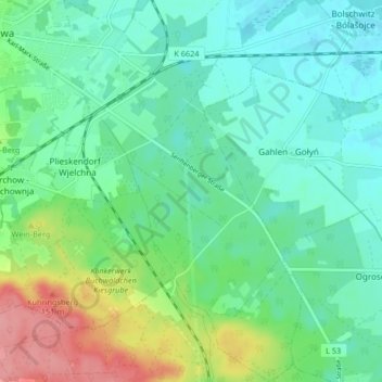
Name: Altnau topographic map, elevation, terrain.
Location: Altnau, Calau, Oberspreewald-Lausitz, Brandenburg, Deutschland (51.69992 13.96792 51.75104 14.01915)
Average elevation: 295 ft
Minimum elevation: 210 ft
Maximum elevation: 518 ft
Thank you for supporting this site ❤️
Make a donation
Make a donation
Gear up for your next adventure:
As an Amazon Associate, this site earns from qualifying purchases at no extra cost to you.
Other topographic maps
Click on a map to view its topography, its elevation and its terrain.
Großer Großmanns Berg
Deutschland > Brandenburg > Oberspreewald-Lausitz > Calau
Average elevation: 397 ft