
Thank you for supporting this site ❤️
Make a donation
Make a donation
Gear up for your next adventure:
As an Amazon Associate, this site earns from qualifying purchases at no extra cost to you.
Pattan topographic map
Click on the map to display elevation.
Thank you for supporting this site ❤️
Make a donation
Make a donation
Gear up for your next adventure:
As an Amazon Associate, this site earns from qualifying purchases at no extra cost to you.
About this map
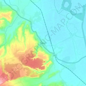
Name: Pattan topographic map, elevation, terrain.
Location: Pattan, Baramulla, Jammu and Kashmir, 193121, India (34.12036 74.51599 34.20036 74.59599)
Average elevation: 5,299 ft
Minimum elevation: 5,171 ft
Maximum elevation: 5,709 ft
Thank you for supporting this site ❤️
Make a donation
Make a donation
Gear up for your next adventure:
As an Amazon Associate, this site earns from qualifying purchases at no extra cost to you.