
Thank you for supporting this site ❤️
Make a donation
Make a donation
Gear up for your next adventure:
As an Amazon Associate, this site earns from qualifying purchases at no extra cost to you.
Pool topographic map
Click on the map to display elevation.
Thank you for supporting this site ❤️
Make a donation
Make a donation
Gear up for your next adventure:
As an Amazon Associate, this site earns from qualifying purchases at no extra cost to you.
About this map
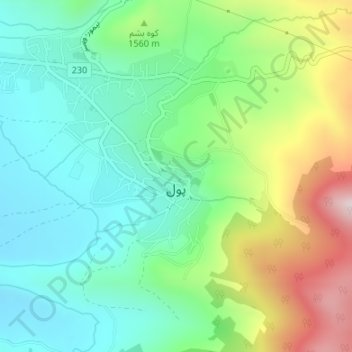
Name: Pool topographic map, elevation, terrain.
Location: Pool, بخش کجور, Nowshahr County, Mazandaran Province, Iran (36.39102 51.58675 36.40022 51.59793)
Average elevation: 4,974 ft
Minimum elevation: 4,426 ft
Maximum elevation: 6,129 ft
Thank you for supporting this site ❤️
Make a donation
Make a donation
Gear up for your next adventure:
As an Amazon Associate, this site earns from qualifying purchases at no extra cost to you.