
Brimfield topographic map
Interactive map
Click on the map to display elevation.
About this map
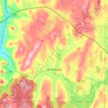
Name: Brimfield topographic map, elevation, terrain.
Average elevation: 804 ft
Minimum elevation: 351 ft
Maximum elevation: 1,188 ft
Hampden County trails, hiking, mountain biking, running and outdoor activities
Other topographic maps
Click on a map to view its topography, its elevation and its terrain.
Mittineague
United States > Massachusetts > Hampden County > West Springfield
Average elevation: 161 ft
Palmer Green Estates
United States > Massachusetts > Hampden County > Palmer
Average elevation: 459 ft
Victory Lake Dam
United States > Massachusetts > Hampden County > Camp Spruce Hill
Average elevation: 1,040 ft
Skyland
United States > Massachusetts > Hampden County > Tolland > Skyland
Average elevation: 1,211 ft