
Make a donation
Gear up for your next adventure:
As an Amazon Associate, this site earns from qualifying purchases at no extra cost to you.
Iráizoz topographic map
Click on the map to display elevation.
Make a donation
Gear up for your next adventure:
As an Amazon Associate, this site earns from qualifying purchases at no extra cost to you.
Iráizoz
El río Ulzama atraviesa el sur del término concejil; la topografía es relativamente suave: el núcleo histórico se sitúa en una suave pendiente con el centro a 548 msnm; los lados de la V ascienden hacia Mortua, alcanzando los 730 msnm el lado oeste y 600 el lado este; en el extremo sudeste del término concejil se encuentra la monte Arañotz con una altitud de 840 msnm.
Make a donation
Gear up for your next adventure:
As an Amazon Associate, this site earns from qualifying purchases at no extra cost to you.
About this map
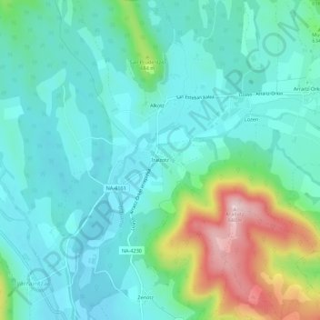
Name: Iráizoz topographic map, elevation, terrain.
Location: Iráizoz, Ulzama, Navarra, 31779, España (42.97324 -1.69350 43.01324 -1.65350)
Average elevation: 1,946 ft
Minimum elevation: 1,713 ft
Maximum elevation: 2,713 ft
Make a donation
Gear up for your next adventure:
As an Amazon Associate, this site earns from qualifying purchases at no extra cost to you.