
Make a donation
Gear up for your next adventure:
As an Amazon Associate, this site earns from qualifying purchases at no extra cost to you.
Hesselberg topographic map
Click on the map to display elevation.
Make a donation
Gear up for your next adventure:
As an Amazon Associate, this site earns from qualifying purchases at no extra cost to you.
Hesselberg
Die tiefbraunen Verwitterungsfarben der höheren Schichten geben dem Braunen Jura seinen Namen. Ursache ist der höhere Eisengehalt. Insgesamt bildet die 135 m mächtige Schicht des Dogger den Hauptanstieg der Hesselberghänge. Die unterste Schicht ist der 75 m mächtige „Opalinuston“ (heute Opalinuston-Formation) (Dogger alpha). Die Unebenheiten der Wiesen sind die Folge von Hangabrutschungen; die Böden dieses Bereichs sind sehr rutschgefährdet. Über dem Opalinuston folgt die 40 m mächtige Schicht des „Eisensandstein“ beziehungsweise der Eisensandstein-Formation (Dogger beta). Diese Schicht ist wegen ihres steilen Anstiegs besonders markant. Da der Opalinuston wasserundurchlässig ist, hat sich am Übergang zum Eisensandstein ein Quellhorizont gebildet. Die Schichten des Dogger gamma (Wedelsandstein-Formation mit Sowerbyi-Bank an der Basis), des Dogger delta („Ostreenkalk“ beziehungsweise Ostreenkalk-Formation) (4 m) und des Dogger epsilon (Sengenthal-Formation) (2 m) sind reich an Versteinerungen. Den Abschluss des Doggers bildet der nur 2 m mächtige „Ornatenton“ (jetzt Ornatenton-Formation) (Dogger zeta). Diese geringmächtige Schicht bildet eine Terrasse um den Hesselberg. Auf ihrer Südseite wurden die Häuser der Volkshochschule erbaut.
Make a donation
Gear up for your next adventure:
As an Amazon Associate, this site earns from qualifying purchases at no extra cost to you.
About this map
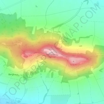
Name: Hesselberg topographic map, elevation, terrain.
Average elevation: 1,722 ft
Minimum elevation: 1,421 ft
Maximum elevation: 2,251 ft
Make a donation
Gear up for your next adventure:
As an Amazon Associate, this site earns from qualifying purchases at no extra cost to you.