
Charsadda topographic map
Click on the map to display elevation.
Charsadda
Chārsadda (Pashto: چارسده; pronounce; Urdu: چارسدہ; pronounce) is a town and headquarters of Charsadda District, in the Khyber Pakhtunkhwa province of Pakistan. It is the 85th-largest city of Pakistan, according to 2017 census. Located in the Valley of Peshawar, Charsadda lies about 29 kilometres (18 mi) from the provincial capital of Peshawar at an altitude of 276 metres (906 ft). The total area of Charsadda District measures about 996 square Km. The district is geographically organized into two primary parts: Hashtnagar (Pashto: Ashnaghar) and Do Aaba (Pashto: Duaba).
About this map
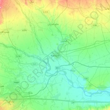
Name: Charsadda topographic map, elevation, terrain.
Average elevation: 1,040 ft
Minimum elevation: 935 ft
Maximum elevation: 1,368 ft
Other topographic maps
Click on a map to view its topography, its elevation and its terrain.
Munda Headworks
Pakistan > Khyber Pakhtunkhwa > Charsadda District > Shabqadar
Average elevation: 1,276 ft
Swat
Pakistan > Khyber Pakhtunkhwa > Charsadda District > بانڈہ سیداں > بِجلۍ کورونه
Average elevation: 1,214 ft
Swat
Pakistan > Khyber Pakhtunkhwa > Charsadda District > بانڈہ سیداں > بِجلۍ کورونه
Average elevation: 1,214 ft