
Make a donation
Gear up for your next adventure:
As an Amazon Associate, this site earns from qualifying purchases at no extra cost to you.
Albstadt topographic map
Click on the map to display elevation.
Make a donation
Gear up for your next adventure:
As an Amazon Associate, this site earns from qualifying purchases at no extra cost to you.
Albstadt
Albstadt is spread across a variety of hills and valleys, its elevation ranges between 614 m (2,014 ft) above sea level and 966 m (3,169 ft). One valley is the river Schmiecha, a left-hand tributary of the Danube, a second valley is the river of upper Eyach, a tributary of the Neckar.
Make a donation
Gear up for your next adventure:
As an Amazon Associate, this site earns from qualifying purchases at no extra cost to you.
About this map
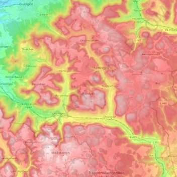
Name: Albstadt topographic map, elevation, terrain.
Average elevation: 2,671 ft
Minimum elevation: 1,677 ft
Maximum elevation: 3,245 ft
Make a donation
Gear up for your next adventure:
As an Amazon Associate, this site earns from qualifying purchases at no extra cost to you.
Other topographic maps
Click on a map to view its topography, its elevation and its terrain.
Hohenzollern Castle
Germany > Baden-Württemberg > Zollernalbkreis > Bisingen
Average elevation: 2,073 ft