Geolocate

Périgny topographic map

Interactive map

Click on the map to display elevation.

About this map

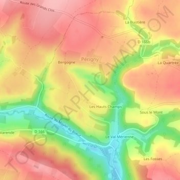
Name: Périgny topographic map, elevation, terrain.

Location: Périgny, Vire, Calvados, Normandie, France métropolitaine, 14770, France (48.90612 -0.61833 48.92979 -0.59243)

Average elevation: 643 ft

Minimum elevation: 394 ft

Maximum elevation: 797 ft

En 2010, le climat de la commune est de type climat océanique franc, selon une étude du CNRS s'appuyant sur une série de données couvrant la période 1971-2000. En 2020, Météo-France publie une typologie des climats de la France métropolitaine dans laquelle la commune est exposée à un climat océanique et est dans la région climatique Normandie (Cotentin, Orne), caractérisée par une pluviométrie relativement élevée (850 mm/a) et un été frais (15,5 °C) et venté. Parallèlement le GIEC normand, un groupe régional d’experts sur le climat, différencie quant à lui, dans une étude de 2020, trois grands types de climats pour la région Normandie, nuancés à une échelle plus fine par les facteurs géographiques locaux. La commune est, selon ce zonage, exposée à un « climat contrasté des collines », correspondant au Bocage normand, bien arrosé, voire très arrosé sur les reliefs les plus exposés au flux d’ouest, et frais en raison de l’altitude.

Wikipedia (CC-BY-SA 3.0)

Other topographic maps

Click on a map to view its topography, its elevation and its terrain.

Chasles

France > Normandie > Calvados > Sainte-Marguerite-d'Elle

Chasles, Sainte-Marguerite-d'Elle, Bayeux, Calvados, Normandie, France métropolitaine, 14330, France

Average elevation: 75 ft

Reviers

France > Normandie > Calvados

Reviers, Caen, Calvados, Normandie, France métropolitaine, 14470, France

Average elevation: 105 ft

Vieux-Bourg

France > Normandie > Calvados

Vieux-Bourg, Lisieux, Calvados, Normandie, France métropolitaine, 14130, France

Average elevation: 331 ft

Courseulles-sur-Mer

France > Normandie > Calvados

Courseulles-sur-Mer, Caen, Calvados, Normandie, France métropolitaine, 14470, France

Average elevation: 62 ft

Castilly

France > Normandie > Calvados > Isigny-sur-Mer

Castilly, Isigny-sur-Mer, Bayeux, Calvados, Normandie, France métropolitaine, 14330, France

Average elevation: 115 ft

Langrune-sur-Mer

France > Normandie > Calvados

Langrune-sur-Mer, Caen, Calvados, Normandie, France métropolitaine, 14830, France

Average elevation: 49 ft

La Villette

France > Normandie > Calvados

La Villette, Vire, Calvados, Normandie, France métropolitaine, 14570, France

Average elevation: 673 ft

Mont Myrrha

France > Normandie > Calvados > Falaise

Mont Myrrha, Falaise, Caen, Calvados, Normandie, France métropolitaine, 14700, France

Average elevation: 531 ft

L'Eglise

France > Normandie > Calvados > Basseneville

L'Eglise, Basseneville, Lisieux, Calvados, Normandie, France métropolitaine, 14670, France

Average elevation: 26 ft

Lisieux

France > Normandie > Calvados

Lisieux, Calvados, Normandie, France métropolitaine, 14100, France

Average elevation: 318 ft

Morières

France > Normandie > Calvados > Grisy > Morières

Morières, Grisy, Vendeuvre, Caen, Calvados, Normandie, France métropolitaine, 14170, France

Average elevation: 164 ft

Castillon

France > Normandie > Calvados

Castillon, Bayeux, Calvados, Normandie, France métropolitaine, 14490, France

Average elevation: 328 ft

Montigny

France > Normandie > Calvados > Montigny

Montigny, Caen, Calvados, Normandie, France métropolitaine, 14210, France

Average elevation: 528 ft

Clécy

France > Normandie > Calvados > Clécy

Clécy, Caen, Calvados, Normandie, France métropolitaine, 14570, France

Average elevation: 466 ft

Saint-Lambert

France > Normandie > Calvados

Saint-Lambert, Caen, Calvados, Normandie, France métropolitaine, 14570, France

Average elevation: 591 ft

Caen

France > Normandie > Calvados

Caen, Calvados, Normandie, France métropolitaine, 14000, France

Average elevation: 115 ft

Lison

France > Normandie > Calvados

Lison, Bayeux, Calvados, Normandie, France métropolitaine, 14330, France

Average elevation: 108 ft

Anisy

France > Normandie > Calvados

Anisy, Caen, Calvados, Normandie, France métropolitaine, 14610, France

Average elevation: 187 ft

Deauville

France > Normandie > Calvados

Deauville, Lisieux, Calvados, Normandie, France métropolitaine, 14800, France

Average elevation: 59 ft

Presles

France > Normandie > Calvados > Valdallière

Presles, Valdallière, Vire, Calvados, Normandie, France métropolitaine, 14410, France

Average elevation: 600 ft

Vire

France > Normandie > Calvados > Vire Normandie

Vire, Vire Normandie, Vire, Calvados, Normandie, France métropolitaine, 14500, France

Average elevation: 512 ft

Jurques

France > Normandie > Calvados > Dialan sur Chaîne

Jurques, Dialan sur Chaîne, Vire, Calvados, Normandie, France métropolitaine, 14260, France

Average elevation: 738 ft

Blay

France > Normandie > Calvados

Blay, Bayeux, Calvados, Normandie, France métropolitaine, 14400, France

Average elevation: 161 ft