Geolocate

Igueben topographic map

Click on the map to display elevation.

About this map

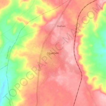
Name: Igueben topographic map, elevation, terrain.

Location: Igueben, Iguegben, Edo State, Nigeria (6.56186 6.20245 6.64186 6.28245)

Average elevation: 869 ft

Minimum elevation: 594 ft

Maximum elevation: 1,043 ft

Gear up for your next adventure:

🧭Orienteering Set - Complete compass and map reading kit
☀️Outdoor Sunscreen - High protection sunscreen for outdoor activities
🧤Tactile Hiking Gloves - Keep hands warm while operating GPS and smartphone screens
🥾Women's Hiking Boots - Top-rated trail boots with ankle support and superior grip
🔦Compact Flashlight - Reliable flashlight for emergencies

As an Amazon Associate, this site earns from qualifying purchases at no extra cost to you.