Geolocate

Calca topographic map

Click on the map to display elevation.

About this map

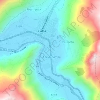
Name: Calca topographic map, elevation, terrain.

Location: Calca, Province of Calca, Cusco, 08120, Peru (-13.34935 -71.97276 -13.30935 -71.93276)

Average elevation: 10,486 ft

Minimum elevation: 9,557 ft

Maximum elevation: 12,949 ft

Gear up for your next adventure:

🛠️Outdoor Gear Repair Kit - Essential tools to fix gear on the trail
Backpacking Tent - Lightweight and durable tent for multi‑day hikes
🌡️Portable Weather Meter - Track weather conditions on the trail
🗻Climbing Gear Basics - Essential gear for beginner climbers
❄️Traction Cleats - Prevent slips on icy trails during winter hikes

As an Amazon Associate, this site earns from qualifying purchases at no extra cost to you.