
Make a donation
Gear up for your next adventure:
As an Amazon Associate, this site earns from qualifying purchases at no extra cost to you.
Khost topographic map
Click on the map to display elevation.
Make a donation
Gear up for your next adventure:
As an Amazon Associate, this site earns from qualifying purchases at no extra cost to you.
Khost
Khost has a semi-arid climate (Köppen BSk though very close to qualifying as BSh). Khost is located in the "Khost Bowl", a valley with lower elevation than the surrounding highlands, because of which it is known for its pleasant weather. With a January average of 4.8 °C (40.6 °F), Khost has noticeably milder winters, as compared to the much harsher and snowy winters of the surrounding higher towns to the north, west, and south (listed anticlockwise): Parachinar, Tari Mangal, Aryob, Tsamkani, Khandkhel, Gardez, Zurmat, Sharana, Zerok, Urgun, Angur Ada, Kaniguram, and Razmak. However, frosts are still frequent in Khost during the mornings.
Make a donation
Gear up for your next adventure:
As an Amazon Associate, this site earns from qualifying purchases at no extra cost to you.
About this map
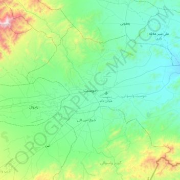
Name: Khost topographic map, elevation, terrain.
Location: Khost, Khost District, Khost Province, 2501, Afghanistan (33.17914 69.76064 33.49914 70.08064)
Average elevation: 4,377 ft
Minimum elevation: 3,317 ft
Maximum elevation: 8,442 ft
Make a donation
Gear up for your next adventure:
As an Amazon Associate, this site earns from qualifying purchases at no extra cost to you.