
Thank you for supporting this site ❤️
Make a donation
Make a donation
Gear up for your next adventure:
As an Amazon Associate, this site earns from qualifying purchases at no extra cost to you.
Oneglie topographic map
Click on the map to display elevation.
Thank you for supporting this site ❤️
Make a donation
Make a donation
Gear up for your next adventure:
As an Amazon Associate, this site earns from qualifying purchases at no extra cost to you.
About this map
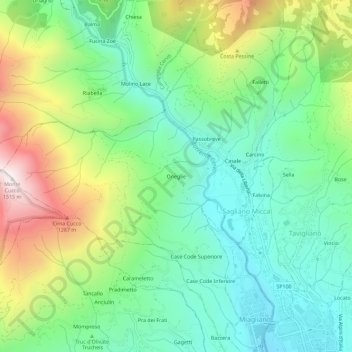
Name: Oneglie topographic map, elevation, terrain.
Location: Oneglie, Sagliano Micca, Biella, Piëmont, 13816, Italië (45.60972 8.01192 45.64972 8.05192)
Average elevation: 2,759 ft
Minimum elevation: 1,654 ft
Maximum elevation: 4,961 ft
Thank you for supporting this site ❤️
Make a donation
Make a donation
Gear up for your next adventure:
As an Amazon Associate, this site earns from qualifying purchases at no extra cost to you.