
Thank you for supporting this site ❤️
Make a donation
Make a donation
Gear up for your next adventure:
As an Amazon Associate, this site earns from qualifying purchases at no extra cost to you.
Mukombu topographic map
Click on the map to display elevation.
Thank you for supporting this site ❤️
Make a donation
Make a donation
Gear up for your next adventure:
As an Amazon Associate, this site earns from qualifying purchases at no extra cost to you.
About this map
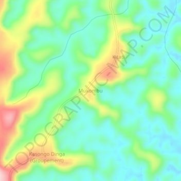
Name: Mukombu topographic map, elevation, terrain.
Location: Mukombu, Kwango, Democratic Republic of the Congo (-4.99039 16.90186 -4.95039 16.94186)
Average elevation: 1,677 ft
Minimum elevation: 1,427 ft
Maximum elevation: 2,201 ft
Thank you for supporting this site ❤️
Make a donation
Make a donation
Gear up for your next adventure:
As an Amazon Associate, this site earns from qualifying purchases at no extra cost to you.