Geolocate

Dasing topographic map

Click on the map to display elevation.

About this map

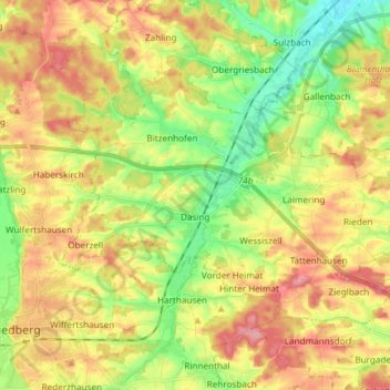
Name: Dasing topographic map, elevation, terrain.

Location: Dasing, Landkreis Aichach-Friedberg, Bavaria, 86453, Germany (48.35676 10.99547 48.42186 11.14438)

Average elevation: 1,634 ft

Minimum elevation: 1,470 ft

Maximum elevation: 1,811 ft

Other topographic maps

Click on a map to view its topography, its elevation and its terrain.

Haunswies

Germany > Bavaria > Landkreis Aichach-Friedberg

Average elevation: 1,644 ft

Pichl

Germany > Bavaria > Landkreis Aichach-Friedberg

Average elevation: 1,565 ft

Lindl

Germany > Bavaria > Landkreis Aichach-Friedberg

Average elevation: 1,604 ft

Gear up for your next adventure:

🍳Camping Cook Set - Complete cookware for outdoor meals
Backpacking Tent - Lightweight and durable tent for multi‑day hikes
🛌Ultralight Sleeping Bags - Compact down bags for cold nights in the wilderness
☀️Outdoor Sunscreen - High protection sunscreen for outdoor activities
🪶Wildlife Field Guides - Learn animal tracking and species ID

As an Amazon Associate, this site earns from qualifying purchases at no extra cost to you.