
Make a donation
Gear up for your next adventure:
As an Amazon Associate, this site earns from qualifying purchases at no extra cost to you.
Sülz topographic map
Click on the map to display elevation.
Make a donation
Gear up for your next adventure:
As an Amazon Associate, this site earns from qualifying purchases at no extra cost to you.
Sülz
Quer durch den Stadtteil verlaufen das Weyertal und die ehemalige Kaiserstraße, die mit der Eingemeindung in Sülzburgstraße und in ihrer Verlängerung ab der Luxemburger Straße in Gottesweg umbenannt wurde. Die Sülzburgstraße bildet seit der Jahrhundertwende zwischen Berrenrather und Luxemburger Straße eine der Einkaufsstraßen der Sülzer sowie der benachbarten Klettenberger, und in dieser Höhe haben sich auch in den großen Nachbarstraßen zahlreiche Geschäfte angesiedelt, so dass dieses Carré das Zentrum von Sülz bildet.
Make a donation
Gear up for your next adventure:
As an Amazon Associate, this site earns from qualifying purchases at no extra cost to you.
About this map
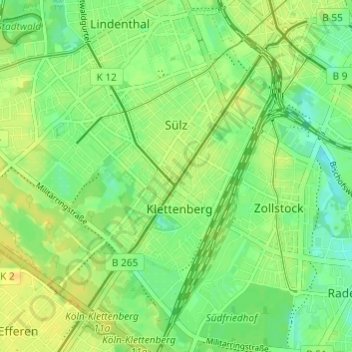
Name: Sülz topographic map, elevation, terrain.
Location: Sülz, Lindenthal, Köln, Nordrhein-Westfalen, 50937, Deutschland (50.89832 6.88000 50.92834 6.94046)
Average elevation: 180 ft
Minimum elevation: 141 ft
Maximum elevation: 213 ft
Make a donation
Gear up for your next adventure:
As an Amazon Associate, this site earns from qualifying purchases at no extra cost to you.
Other topographic maps
Click on a map to view its topography, its elevation and its terrain.
Make a donation
Gear up for your next adventure:
As an Amazon Associate, this site earns from qualifying purchases at no extra cost to you.