
Make a donation
Gear up for your next adventure:
As an Amazon Associate, this site earns from qualifying purchases at no extra cost to you.
Mentone topographic map
Click on the map to display elevation.
Make a donation
Gear up for your next adventure:
As an Amazon Associate, this site earns from qualifying purchases at no extra cost to you.
Mentone
Mentone is located in southwestern Loving County at an elevation of 2,684 feet (818 m). It is situated on State Highway 302, 77 miles (124 km) west of Odessa and 22 miles (35 km) north of Pecos. According to the U.S. Census Bureau, the Mentone CDP has an area of 0.2 square miles (0.4 km2), all land. The town is 1.5 miles (2.4 km) east of the Pecos River.
Make a donation
Gear up for your next adventure:
As an Amazon Associate, this site earns from qualifying purchases at no extra cost to you.
About this map
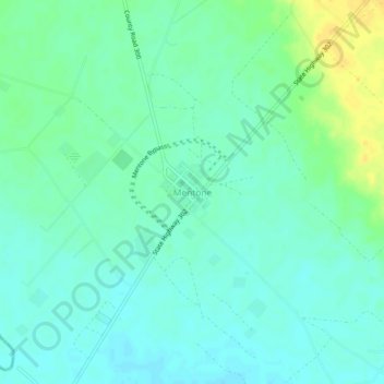
Name: Mentone topographic map, elevation, terrain.
Location: Mentone, Loving County, Texas, 79754, United States (31.68680 -103.61879 31.72680 -103.57879)
Average elevation: 2,694 ft
Minimum elevation: 2,667 ft
Maximum elevation: 2,753 ft
Make a donation
Gear up for your next adventure:
As an Amazon Associate, this site earns from qualifying purchases at no extra cost to you.