Geolocate

Para topographic map

Click on the map to display elevation.

About this map

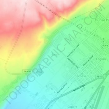
Name: Para topographic map, elevation, terrain.

Location: Para, Tacna, 23006, Perú (-18.05099 -70.31085 -18.01099 -70.27085)

Average elevation: 1,742 ft

Minimum elevation: 1,309 ft

Maximum elevation: 2,418 ft

Other topographic maps

Click on a map to view its topography, its elevation and its terrain.

Urbanización Bacna Ríos

Perú > Tacna > Tacna

Average elevation: 1,906 ft

Óvalo Cristo Rey

Perú > Tacna > Tacna

Average elevation: 1,654 ft

Gear up for your next adventure:

🌡️Handheld Weather Meters - Measure wind, temp, and pressure for safe mountain travel
🔌Solar Panel Charger - Charge gear sustainably outdoors
🎒Waterproof Dry Bags - Keep your electronics and maps dry inside your pack
🧭GPS Watch Accessories - Bands and chargers for GPS watches
🛰️Satellite Messengers - Emergency SOS and two-way messaging for off-grid adventures

As an Amazon Associate, this site earns from qualifying purchases at no extra cost to you.