
Limestone topographic map
Click on the map to display elevation.
About this map
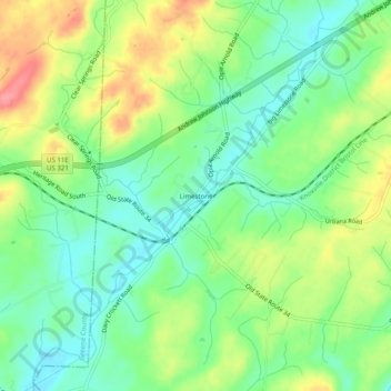
Name: Limestone topographic map, elevation, terrain.
Average elevation: 1,467 ft
Minimum elevation: 1,355 ft
Maximum elevation: 1,644 ft
Washington County trails, hiking, mountain biking, running and outdoor activities
Other topographic maps
Click on a map to view its topography, its elevation and its terrain.
Johnson City
United States > Tennessee > Washington County
Johnson City occupies a broad Appalachian valley in northeastern Tennessee, where the smoother urban floor around Sinking Creek and Brush Creek sits at roughly 1,600 feet (488 meters) above sea level and is framed by progressively higher, more rugged terrain. The landscape reflects the Ridge-and-Valley…
Average elevation: 1,683 ft